Not All Trees Live in Forests: The Benefits We Often Overlook

When people think about trees and conservation, they often imagine large forests, national parks, or protected areas. But many important trees do not grow inside forests.
They grow beside farms, along roads, near villages, around homes, beside rivers, and across dry rural landscapes. These trees may look scattered, but they quietly support people and nature every day.
They provide shade in hot places. They help protect soil from erosion. They support birds, insects, and other small species. They store carbon, improve local climate conditions, and provide useful resources such as fruits, fuelwood, fodder, and timber.
In many rural areas, these trees are not just part of the landscape. They are part of people’s daily lives.
The Problem: Many Useful Trees Are Missing from the Map
One challenge in conservation is that not everything valuable is easy to see in official data.
Traditional forest maps usually focus on large areas of forest. But scattered trees in farms, villages, roadsides, and dryland landscapes are much harder to identify. Because of this, they are often left out of forest monitoring, land-use planning, and climate discussions.
When these trees are not mapped, their value can be underestimated.
This is important because conservation decisions often depend on data. If a tree does not appear on a map, it may also disappear from policy, planning, and investment.
How Satellite Data Can Help
Remote sensing gives us a way to see the land from above. By using satellite images, we can study vegetation across large areas without needing to visit every single field or village.
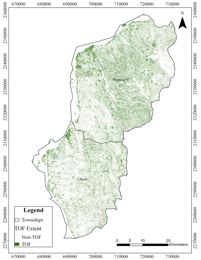
In my Master’s research, I used satellite imagery and spatial data to map scattered trees in Chauk and Nyaung-U Townships in Myanmar’s Central Dry Zone. This region is dry, hot, and highly dependent on land-based livelihoods, which makes trees especially important for climate resilience and rural communities.
The study used Sentinel-2 satellite imagery to detect vegetation, NDWI to remove water areas, fractional vegetation cover to understand vegetation density, and canopy height data to better separate trees from crops and other low vegetation. After mapping tree cover, forest areas were removed so that the remaining trees outside formal forests could be identified.
The goal was simple: to make overlooked trees visible.
What the Study Found
The results showed that scattered trees are a major part of the landscape.
In Chauk and Nyaung-U Townships, trees outside forests covered about 35,827 hectares, or around 15% of the total study area. They also made up about 82% of all mapped tree cover, meaning most trees in the study area were actually outside formal forest areas. The study also found that adding canopy height data improved tree cover mapping accuracy from 45% to 80%.
This finding matters because it shows that many important trees can exist outside the places we normally call “forests.”
Why This Matters
Conservation is not only about protecting large forests. It is also about understanding everyday landscapes where people live, farm, and work.
Scattered trees can support climate adaptation, biodiversity, soil protection, rural livelihoods, and land restoration. In dry regions, they can help reduce heat stress, provide shade, and support farming systems.
If we want better conservation planning, we need better ways to recognize these trees. Satellite data and GIS can help us see what is often missed on the ground and in official statistics.
A Bigger Lesson
This work taught me that conservation is not always about dramatic landscapes. Sometimes, it is about ordinary trees in ordinary places.
A tree beside a farm may not look like a forest.
A row of trees along a road may not appear important on a national map.
A few trees around a village may seem too small to count.
But together, these trees can support people, protect land, and contribute to climate resilience.
Not all trees live in forests. But many of them still matter.
Further Reading
This article is based on my Master’s thesis at Michigan State University:
The Extent of Trees Outside Forests Using Sentinel-2 and Canopy Height Data: The Central Dry Zone of Myanmar
Read the full thesis here:
https://d.lib.msu.edu/etd/52737/OBJ/download